aviation explorer
AVIATION WEATHER MAPS - LIVE FLIGHT AND AIRPORT DELAY MAPS - REAL TIME PILOT WEATHER MAPS - TAF'S - NOAA
jet cockpit
business jet

THE BELOW LINKS CONTAIN DETAILED AIRLINE, MILITARY JETS, TEST AIRCRAFT, AIRPLANE FACT SHEETS AND AEROSPACE INFORMATION

airplanes

THE BELOW LINKS CONTAIN AVIATION, MILITARY, AIRCRAFT VIDEOS, PICTURES, FACTS, INFORMATION, AUDIO, HISTORY, MOVIES AND PHOTOS

aviation

THE BELOW LINKS CONTAIN FLIGHT TRACKING, AIRPORT INFO, AVIATION PIONEERS, USAF REFERENCES, NTSB FACTS AND AVIATION WEATHER

THE BELOW LINKS CONTAIN INFORMATION ON AIRLINES IN CURRENT SERVICE TODAY AND ALSO BANKRUPT US AIRLINE COMPANIES (DEFUNCT)
Share/Save/Bookmark
cheap rc airplanes

AVIATION WEATHER MAPS - FLIGHT AND AIRPORT DELAY MAPS
REAL TIME PILOT WEATHER MAPS - TAF'S - NOAA

weather advisories
aviation weather radar maps
METAR weather
aviation turbulance map

Accurate and up-to-date aviation weather maps and information is essential to the safe and economic operation of any airport, whether large or small. Few things change faster than the weather. Without weather data, your airport and certain scheduled flights cannot operate under IFR (Instrument Flight Rules) conditions, and this can cost your airport or airline money in lost landing fees and services.

Flight information is provided by FlightStats, and is subject to the FlightStats Terms of Use.

Flight information is provided by FlightStats, and is subject to the FlightStats Terms of Use.

Current Surface Weather Map


Surface Forcast Map Forcast Precipitation Map

Aircraft real time surface data map

IFR and VFR Real Time Map Flight Rules Map

Current map of air travel airport delays
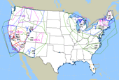
CURRENT AIRPORT DELAYS


ADVANCED INFARED SATELLITE MAP
ADVANCED INFRARED SATELLITE MAP

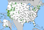
NOAA's AVIATION WEATHER REPORTS FOR TODAY...
Turbulance | Icing | Convection | Winds/Temps | Prog Charts | Java Tools
METARS | TAFs | PIREPs | AIR/SIGMETs | Satellite | Radar | Advisories (USA)


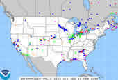
TERMINAL AERODROME FORECAST FROM THE NOAA (TAF)

Terminal Aerodrome forecast supplied by the National Weather Service.
A Terminal Aerodrome Forecast (TAF) is a concise statement of the expected meteorological conditions at an airport during a specified period usually 24 hours. The above TAF link is the one used in the United States. TAFs use the same weather code found in METAR weather reports. The TAF code uses the ICAO four-letter location identifiers. In the conterminous United States, the three-letter identifier is prefixed with a K. For example SEA (Seattle) becomes KSEA. Elsewhere, the first one or two letters of the ICAO identifier indicate in which region of the world and country (or state) the station is. Pacific locations such as Alaska, Hawaii, and the Marianas islands start with P followed by an A, H, or G respectively. The last two letters reflect the specific station identification. If the location's three-letter identification begins with an A, H, or G, the P is just added to the beginning. If the location's three-letter identification does not begin with an A, H, or G, the last letter is dropped and the P is added to the beginning.


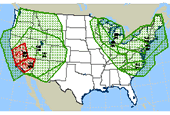
PILOT WEATHER FROM ACCUWEATHER.COM
Decoded METAR weather reports from AccuWeather.
Automatic Weather Observing Reporting stations for pilots in the United States.


WEATHER MEASUREMENT RECORDS AND FACTS


Fastest surface wind speed: 231 miles per hour

(Mount Washington, New Hampshire; April 12, 1934)

Fastest tornado winds: 286 miles per hour
(Wichita Falls, Texas; April 2, 1958)

Greatest rainfall in a day: 73.62 inches
(RØunion, Indian Ocean; March 15, 1952)

Greatest rainfall in a year: 1,041 inches
(Assam, India; August 1880-1881)

Greatest snowfall in a day: 75.8 inches
(Silver Lake, Colorado; April 14-15, 1921)

Greatest snowfall in a single storm: 189 inches
(Mt. Shasta, California; February 13-19, 1959)

Largest hailstone: 17.5 inches
(Coffeyville, Kansas; September 3, 1970)


The Aviation Digital Data Service (ADDS) makes available to the aviation community text, digital and graphical forecasts, analyses, and observations of aviation-related weather variables. ADDS is a joint effort of NCAR Research Applications Program (RAP), Global Systems Division (GSD) of NOAA's Earth System Research Laboratory (ESRL), and the National Centers for Environmental Prediction (NCEP) Aviation Weather Center (AWC).

© AviationExplorer.com - The Website For Aviation Enthusiasts
F22Fighter.com Topsites List
flight sim sites
AVIATION TOP 100 - www.avitop.com Avitop.com
Best Aviation Sites