AREA 51 GROOM LAKE NEVADA - UFO USAF TESTING SECRET BASE - CLASSIFIED DOCUMENTS HISTORY FACTS PICTURES
THE BELOW LINKS CONTAIN DETAILED AIRLINE, MILITARY JETS, TEST AIRCRAFT, AIRPLANE FACT SHEETS AND AEROSPACE INFORMATION  THE BELOW LINKS CONTAIN AVIATION, MILITARY, AIRCRAFT VIDEOS, PICTURES, FACTS, INFORMATION, AUDIO, HISTORY, MOVIES AND PHOTOS  THE BELOW LINKS CONTAIN FLIGHT TRACKING, AIRPORT INFO, AVIATION PIONEERS, USAF REFERENCES, NTSB FACTS AND AVIATION WEATHER THE BELOW LINKS CONTAIN INFORMATION ON AIRLINES IN CURRENT SERVICE TODAY AND ALSO BANKRUPT US AIRLINE COMPANIES (DEFUNCT) |

AREA 51 GROOM LAKE UFO USAF CLASSIFIED DOCUMENTS
NEVADA UFO AIR FORCE FLIGHT TESTING BASE
AREA 51 - SECRET BASE HISTORY FACTS PICTURES
 |
 |
 |
THE HISTORY OF AREA 51 GROOM LAKE
|
 |
Area 51 shares a border with the Yucca Flats region of the Nevada Test Site (NTS), the location of many of the US Department of Energy's nuclear weapons tests. The Yucca Mountain nuclear storage facility is approximately 40 miles (64 km) southwest of Groom Lake.
The designation "Area 51" is contentious, appearing on older maps of the NTS but not newer ones, yet the same naming scheme is used for other parts of the Nevada Test Site.
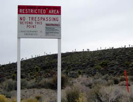
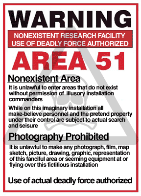
The area is connected to the internal NTS road network, with paved roads leading south to Mercury and west to Yucca Flats. Leading northeast from the lake, the wide and well-maintained Groom Lake Road runs through a pass in the Jumbled Hills. The road formerly led to mines in the Groom basin, but has been improved since their closure. Its winding course runs past a security checkpoint, but the restricted area around the base extends further east. (Unauthorized visitors who travel west on Groom Lake Road are usually observed first by guards located on the hills surrounding the pass, still several miles from the checkpoint). After leaving the restricted area (marked by numerous warning signs stating that "photography is prohibited" and that "use of deadly force is authorized" under the terms of the 1950 McCarran Internal Security Act) Groom Lake Road descends eastward to the floor of the Tikaboo Valley, passing the dirt-road entrances to several small ranches, before converging with State Route 375, the "Extraterrestrial Highway", south of Rachel.
Operations at Groom Lake
Groom Lake is not a conventional airbase, as frontline units are not normally deployed there. It instead appears to be used during the development, testing, and training phases for new aircraft. Once these aircraft have been approved by the United States Air Force or other agencies such as the CIA, operation of that aircraft is generally conducted from a normal air force base. Groom is reported, however, to be the permanent home for a small number of Soviet-designed aircraft (obtained by various means), which are analyzed and used for training purposes.
Soviet spy satellites obtained photographs of the Groom Lake area during the height of the Cold War, and later civilian satellites produced detailed images of the base and its surroundings. These images support only modest conclusions about the base; they depict a nondescript base, long airstrip, hangars and the lake, but nothing that supports some of the claims about underground facilities.
Though no ICAO identifier for the base appears on any official document, in December 2007, airline pilots noticed that the base had appeared in their aircraft navigation systems' latest Jeppesen database revision as "KXTA".
U-2 program
Groom Lake was used for bombing and artillery practice during World War II, but was then abandoned until 1955, when it was selected by Lockheed's Skunk Works team as the ideal location to test the forthcoming U-2 spy plane. The lakebed made an ideal strip from which they could operate the troublesome test aircraft, and the Emigrant Valley's mountain ranges and the NTS perimeter protected the test site from prying eyes and outside interference.
Lockheed constructed a makeshift base at Groom, consisting of little more than a few shelters, workshops and trailer homes in which to house its small team. The first U-2 flew at Groom in August 1955, and U-2s under the control of the CIA began overflights of Soviet territory by mid-1956.
During this period, the NTS continued to perform a series of atmospheric nuclear explosions. U-2 operations throughout 1957 were frequently disrupted by the Plumbbob series of atomic tests, which detonated over two dozen devices at the NTS. The Plumbbob-Hood explosion on July 5 scattered fallout across Groom and forced a temporary evacuation.
As the U-2's primary mission was to fly over the Soviet Union, it operated largely from airbases near the Soviet border, including Incirlik in Turkey, Peshawar in Pakistan, and Bodø, Norway.
Blackbird programs
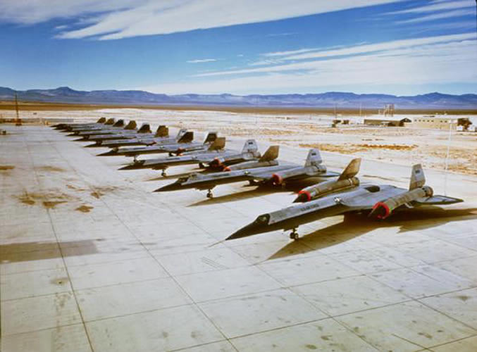
Even before U-2 development was complete, Lockheed began work on its successor, the CIA's OXCART project, a Mach-3 high altitude reconnaissance aircraft, a later variant of which became the famed USAF SR-71 Blackbird. The Blackbird's flight characteristics and maintenance requirements forced a massive expansion of facilities and runways at Groom Lake. By the time the first A-12 Blackbird prototype flew at Groom in 1962, the main runway had been lengthened to 8500 ft (2600 m), and the base boasted a complement of over 1000 personnel. It had fueling tanks, a control tower, and a baseball diamond. Security was greatly enhanced, the small civilian mine in the Groom basin was closed, and the area surrounding the valley was made an exclusive military preserve (where interlopers could be subject to "lethal force"). Groom saw the first flight of all major Blackbird variants: A-12, SR-71, its abortive YF-12 interceptor variant, and the D-21 Blackbird-based drone project. The A-12 would remain at Groom Lake until 1968. Some people say that the Blackbird was scrapped for a new plane called the Aurora, even though the government claims that the latter is just a myth.
Have Blue/F-117 program
The first Have Blue prototype stealth fighter (a smaller cousin of the F-117 Nighthawk) first flew at Groom in December 1977. Testing of a series of ultra-secret prototypes continued there until mid-1981, when testing transitioned to the initial production of F-117 stealth fighters. In addition to flight testing, Groom performed radar profiling, F-117 weapons testing, and was the location for training of the first group of frontline USAF F-117 pilots. Subsequently, the still highly classified active-service F-117 operations moved to the nearby Tonopah Test Range, and finally to Holloman Air Force Base.Since the F-117 became operational in 1983, operations at Groom Lake have continued unabated. The base and its associated runway system have been expanded, and the daily flights bringing civilian commuters from Las Vegas continue. Some commentators, after examining recent satellite photos of the base, estimate it to have a live-in complement of over 1000 people, with a similar number commuting from Las Vegas. In 1995, the federal government expanded the exclusionary area around the base to include nearby mountains that had hither to afforded the only decent overlook of the base. Subsequently, limited views of the area are available only from the summits of several distant mountains east.
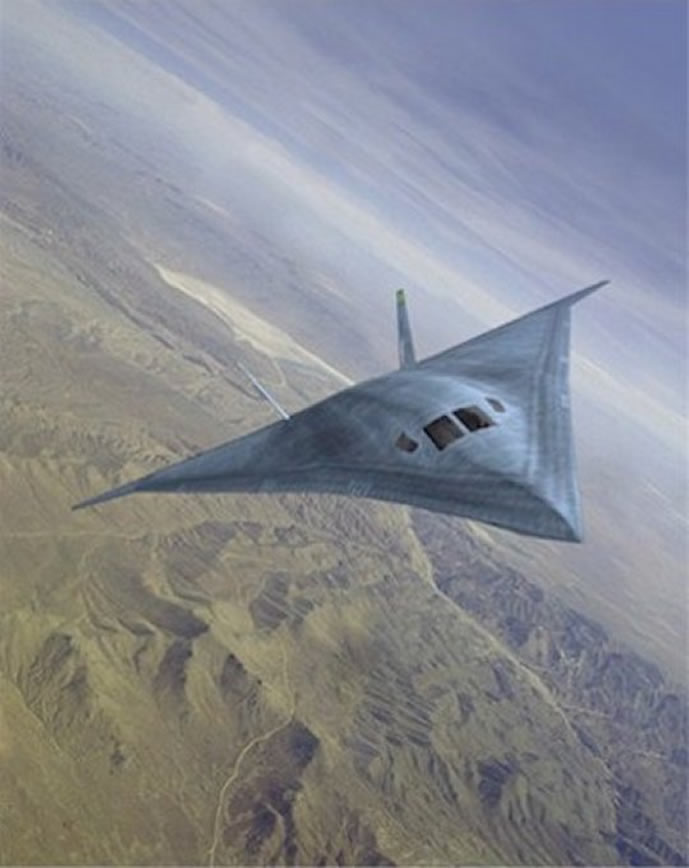
Aircraft that have been tested at Groom include the Northrop Tacit Blue stealth demonstrator, various classified UAVs, and a stealthy cruise missile (most likely the AGM-129 Advanced Cruise Missile). Other rumored Groom test programs include a small stealthy VTOL troop-transport aircraft, the Aurora hypersonic spy plane, a "Stealth Blimp", a secret USAF spaceplane codenamed Blackstar, and replacements for the SR-71 and F-117A.
Area 51 Commuters from Las Vegas Airport
"JANET" "Bland" Callsigns For Aircraft Commuting Passengers to Area 51 (Groom Dry Lake Bed)
USAF uses old Western Airlines Boeing 737s - (See red stripe on fuselage which was old paint scheme of Western Airlines)
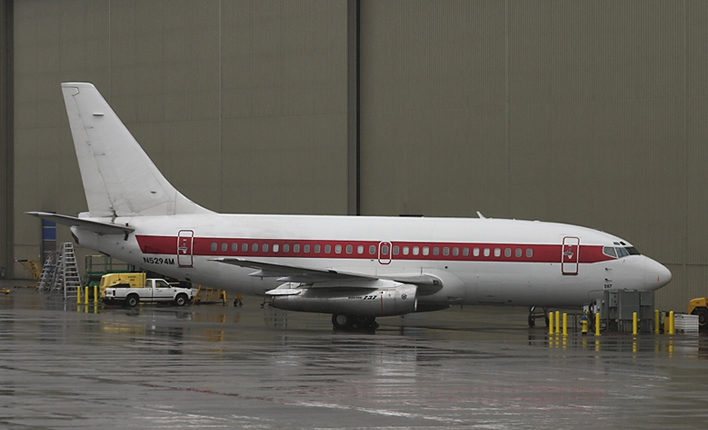 |
Defense contractor EG&G maintains a private terminal at McCarran International Airport in the Las Vegas metropolitan area. A number of unmarked aircraft operate daily shuttle services from McCarran to sites operated by EG&G in the extensive federally controlled lands in southern Nevada. These aircraft reportedly use JANET radio call signs (e.g., "JANET 6") (the JANET airplanes are now using either call sign "Bland" or "JANET" on the radio, and "WWW" on their flight number identifier), said to be an acronym for "Joint Air Network for Employee Transportation" or (perhaps jokingly) "Just Another Non-Existent Terminal". EG&G advertises in the Las Vegas press for experienced military pilots, requiring applicants to be eligible for government security clearance, and that successful applicants can expect to always stay overnight at Las Vegas. These aircraft, painted white with red trim (the livery of now defunct Western Airlines), include six Boeing 737/T-43As and several smaller turboprops. Their tail numbers are registered to the U.S. Air Force. They are reported to shuttle to Groom, Tonopah Test Range, to other locations in the NAFR and NTS, and reportedly to Naval Air Weapons Station China Lake. Observers tracking the number of departures and cars in the private EG&G parking lot at McCarran estimate several thousand JANET commuters each day. These shuttle flights were previously operated by Key Air, which had flown 22,000 passenger trips on 300 flights from Nellis Air Force Base to Tonopah Test Range per month from 1982 until early 1991.
Commuter service is provided along Groom Lake Road by a bus, catering to a small number of employees living in several small communities beyond the NTS boundary (although it is not clear whether these workers are employed at Groom or at other facilities in the NTS). The bus travels Groom Lake Road and stops at Crystal Springs, Ash Springs, and Alamo, and parks at the Alamo court house overnight.
RUNWAYS AND DETAILED AERIAL PHOTO OF AREA 51 GROOM LAKE
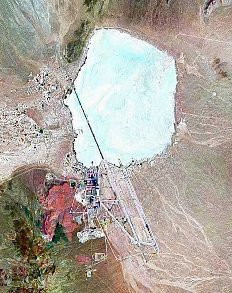 |
The airbase, given the ICAO airport identifier code of KXTA and listed as "Homey Airport" in aviation GPS databases, has seven runways including one that now appears to be closed. The closed runway, 14R/32L, is also by far the longest with a total length of approximately 7,093 meters (23,270 feet), not including stopway. The other runways are two asphalt runways, the 14L/32R with a length of 3,658 meters (12,000 feet) and 12/30 with a length of 1,652 meters (5,420 feet), and four runways located on the salt lake. These four runways are 09L/27R and 09R/27L, which are both approximately 3,489 meters (11,440 feet), and 03L/21R and 03R/21L, which are both approximately 3,057 meters (10,030 feet).
U.S. government's positions on Area 51
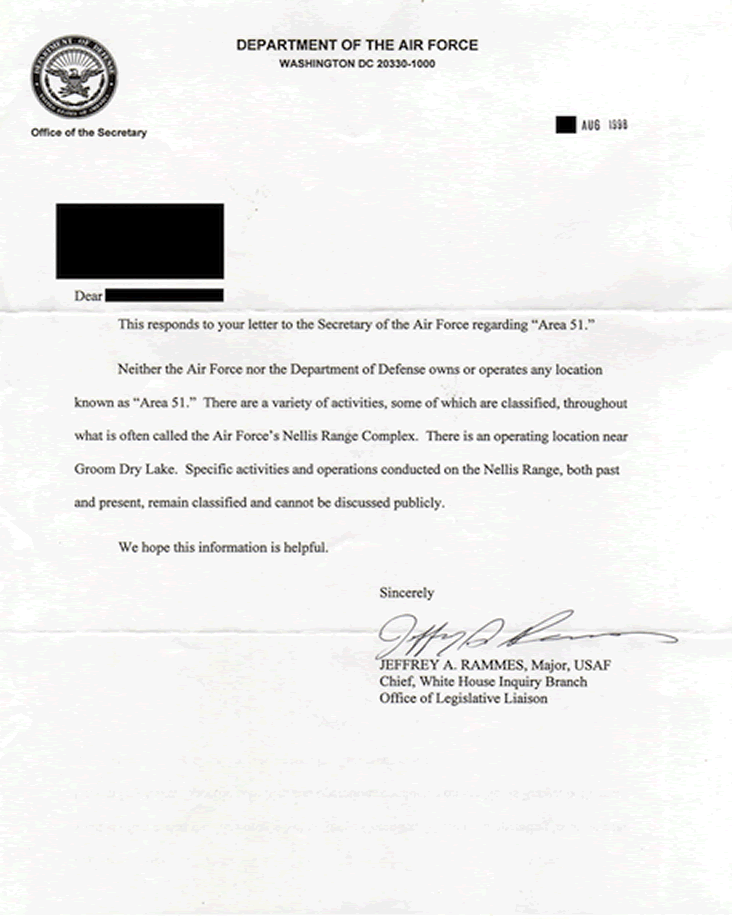
On July 14th, 2003 the Federal Government admited the facility's existence, tacitly conceding that the Air Force has an "operating location" near the lake, but does not provide any further information. The base is conspicuously absent from Federal publications and inquiries to the government regarding the facility are rejected for reasons of national security.
 |
Unlike much of the Nellis range, the area surrounding the lake is permanently off-limits both to civilian and normal military air traffic. The area is protected by radar stations, and unauthorized personnel are quickly expelled. Even military pilots training in the NAFR risk disciplinary action if they accidentally stray into the exclusionary "box" surrounding Groom's airspace.
Perimeter security is provided by uniformed private security guards working for EG&G's security subcontractor Wackenhut, who patrol in desert camouflage Jeep Cherokees and HMMWV vehicles, and more recently, champagne-colored Ford F-150 pickups and gray Chevy 2500 4X4 pickups. Although the guards are armed with M16s, no violent encounters with Area 51 observers have been reported; instead, the guards generally follow visitors near the perimeter and radio for the Lincoln County Sheriff. Deadly force is authorized if violators who attempt to breach the secured area fail to heed warnings to halt. Fines of around $600 seem to be the normal course of action, although some visitors and journalists report receiving follow-up visits from FBI agents. Some observers have been detained on public land for pointing camera equipment at the base. Surveillance is supplemented using buried motion sensors and by HH-60 Pave Hawk helicopters.
The base does not appear on public U.S. government maps the USGS topographic map for the area only shows the long-disused Groom Mine, and the civil aviation chart for Nevada shows a large restricted area, but defines it as part of the Nellis restricted airspace. Similarly the National Atlas page showing federal lands in Nevada does not distinguish between the Groom block and other parts of the Nellis range. Although officially declassified, the original film taken by U.S. Corona spy satellite in the 1960s has been altered prior to declassification; in answer to freedom of information queries, the government responds that these exposures (which map to Groom and the entire NAFR) appear to have been destroyed. Terra satellite images (which were publicly available) were removed from webservers (including Microsoft's "Terraserver") in 2004, and from the monochrome 1 m resolution USGS datadump made publicly available. NASA Landsat 7 images are still available (these are used in the NASA World Wind). Higher resolution (and more recent) images from other satellite imagery providers (including Russian providers and the IKONOS) are commercially available. These show, in considerable detail, the runway marking, base facilities, aircraft, and vehicles.
Nevada's state government, recognizing the folklore surrounding the base might afford the otherwise neglected area some tourism potential, officially renamed the section of State Route 375 near Area 51 "The Extraterrestrial Highway", and posted fancifully illustrated signs along its length.
Although federal property within the base is exempt from state and local taxes, facilities owned by private contractors are not. Area 51 researcher Glenn Campbell claimed in 1994 that the base only declares a taxable value of $2 million to the Lincoln County tax assessor, who is unable to enter the area to perform an assessment.
UFO and other conspiracy theories concerning Area 51
Its secretive nature and undoubted connection to classified aircraft research, together with reports of unusual phenomena, have led Area 51 to become a focus of modern UFO and conspiracy theories. Some of the unconventional activities claimed to be underway at Area 51 include:
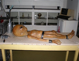
The storage, examination, and reverse engineering of crashed alien spacecraft (including material supposedly recovered at Roswell), the study of their occupants (living and dead), and the manufacture of aircraft based on alien technology. Meetings or joint undertakings with extraterrestrials. The development of exotic energy weapons (for SDI applications or otherwise) or means of weather control. The development of time travel technology. The development of unusual and exotic propulsion systems related to the Aurora Program. Activities related to a supposed shadowy one world government and or the Majestic Twelve organization. Many of the hypotheses concern underground facilities at Groom or at nearby Papoose Lake, and include claims of a transcontinental underground railroad system, a disappearing airstrip (nicknamed the "Cheshire Airstrip", after Lewis Carroll's Cheshire cat) which briefly appears when water is sprayed onto its camouflaged asphalt, and engineering based on alien technology. In 1989, Bob Lazar claimed that he had worked at a facility at Papoose Lake (which he called S-4) on such a U.S. Government flying saucer.
Another hypothesis is that Area 51 is a place which simulates the environment of the moon. In 2000-2001, Fox Television broadcast a show about Apollo moon landing hoax accusations, in which it was suggested that the entire moon landing in 1969 was a hoax and was filmed in parts of Area 51.
Others, however, claim that during the mid 1990s, the most secret work previously done at Groom was quietly moved to other facilities, including Dugway Proving Ground in Utah, and that the continued secrecy around Groom is largely a successful attempt at misdirection.
The 1996 documentary Dreamland directed by Bruce Burgess included an interview with a 71 year old mechanical engineer who claimed to be a former employee at Area 51 during the 1950s, working on a "flying disc simulator" built to train US Pilots, based on a disc originating from a crashed extraterrestrial craft. During his career at Area 51 he claimed to have worked with an extraterrestrial being whose name was "J-Rod", described as a telepathic translator.
Dan Burisch (real name, Dan Crain) claims to have worked on cloning alien viruses at Area 51, also with the alien "J-Rod".
In July 1996, a man named "Victor" announced on Art Bell's Coast to Coast AM radio show that he had a videotape of an alien interrogation which had taken place in Area 51. He claimed that he had made a copy of the tape during a scheduled transfer of analogue videotape files on the base into digital form, and had then smuggled the copy out of Area 51. The video appears to show the head of an alien creature in a dark interrogation room, allegedly using telepathy to communicate with military personnel and scientists. The footage was eventually included in a video documentary entitled Area 51: The Alien Interview.
Area 51 in popular culture
Popular culture usually portrays Area 51 as a haven for aliens. The numerous conspiracy theories surrounding Area 51 have granted it a fairly high profile in popular culture, specifically in the area of science fiction. There have been literally dozens of movies or television shows which deal with fictionalized events or happenings at the site. Perhaps the most well-known example is the 1996 action film Independence Day, in which the complex is shown to have been studying the crashed scout ship from the Roswell UFO incident of 1947. The heroes of the film later make their final attack from the airstrips at the base, and in a nod to established fact, Randy Quaid's character Russell Casse at one point refers to the base not being shown on a state map of Nevada.
The 1998-2001 television series Seven Days took place largely inside the Area 51 complex itself, with the base depicted as being run by a covert National Security Agency operation which used time-travel made possible by alien technology recovered from the 1947 Roswell UFO incident.
Also, in the game RollerCoaster Tycoon 3, one of the parks is called 'Broom Lake' and is run by a group of CIA operatives, and in the MMORPG World of Warcraft, a town in the zone Netherstorm is called 'Area 52'.
Lara Croft infiltrates ‘’’Area 51’’’ in Tomb Raider 3. While searching for an Infada Artefact in the Nevada Desert, Lara crashes a Quad Bike. She is recovered, unconscious, by two Military Police. She is dragged to a High Security Compound, of which is in involvement is some sort of trading with Area 51. Lara escapes the compound hidden within the cargo of a lorry. This then takes Lara to Area 51 where the cargo is shipped. Lara discovers the artefact there, and raids it.
In the popular video game Grand Theft Auto: San Andreas, Area 51 (Parodied as Area 69 in the game) is placed in a large open tract of land, designated as a No-Fly Zone in the Map included in the game case and simply unnamed on the in-game map. A few missions include this zone, with most, if not all, involving secret military projects and relations to extra-terrestrial contact. Outside of the missions, this entering or flying over this area results in an immediate jump to the 5th "Wanted" level and ordinarily death via surface-to-air missiles, Military-Controlled Harriers, and armed guards. This denotes a direct reference to the high level of security and secrecy surrounding Area 51.
© AviationExplorer.com - The Website For Aviation Enthusiasts |